
Mark Hastings hiking in the Cascades
Living north of Seattle in Mukilteo, is an ideal location for hiking the North Cascades. Within an hour, one can drive to several trailheads in the Mountain Loop Highway area between Granite Falls and Darrington. Within an hour and a half a hundred more hikes along Stevens and Snoqualmie pass are available. Within two hours the you can get to trailheads near Mt Baker or Mt Rainier. Although I lived in this area over 20 years, I just began hiking passionately in 2004. (Got hooked)
These days I encourage everyone to get out a do at least a couple hikes during the summer. Few people will ever regret it. I've even talked my teenagers to do a couple hikes with me. If you do go, be prepared.
Hike Pictures
One part of hiking that I enjoy is taking pictures. I'm no more than an amateur photographer, but take pictures to show friends and family. I have compiled a table of most of the hikes that I have taken in the past couple years. It includes length, elevation gain, trailhead coordinates, links to pictures, and links to track logs for some of the hikes. The other links to the left show hike pictures by year of the hike. Another fun thing to do is take sequential pictures and combine then into panoramas. I have had some of these panoramas printed out. One is about 7 feet long! The picture at the top of this page is from 6 or 7 pictures taken from the top of Three Fingers.
A web site call Panoramio allows users to upload pictures for everyone to see. If you enable the Panoramio option in Google Earth you can view the pictures, just look for the small icon that looks like a picture and click on it to see the picture.
GPS and Google Earth
A few years ago my wife gave me a new GPS with downloadable maps for fathers day. It was also much more sensitive than the old one I had, so it worked well even in deep canyons and with a heavy tree cover. If you are thinking of getting one, seriously consider the Garmin GPSmap 60CSx. Before then, I seldom took a GPS with me on a hike. Now I always take it with me and leave it in the logging mode. Some of my Track Logs can be downloaded and viewed with Google Earth. I have also been playing with Google Maps a little. To see a map of all the I have taken so far, check out this Map.
Favorite Hikes
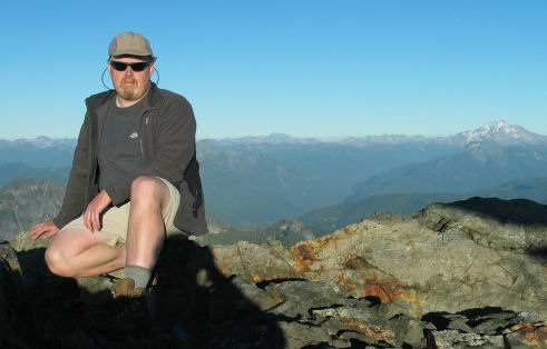
I have enjoyed most of the hikes I've been on since 2003, even the ones that it rained all day. My favorite hike in 2006 was to Three Fingers Peak about 60 miles northwest of Seattle. This hike has some of the best views in the area. You can see all the way across Puget Sound to the west, and past Glacier Peak to the east. The picture to the left is me sitting behind the shack with Glacier Peak in the background. About 2 feet behind me is a 3000 foot drop. Needless to say, this hike is not for people afraid of heights. The shack barely fits on top the south finger. You can't even walk on either side of the shack. The last climb to the top is via three ladders cabled to the rock. At first is doesn't look very safe, but if you take your time it's not to bad. I've heard that some people see the ladders and turn around.
A friend and I made the hike in late September 2006. We met two other hikers on the way up and all four of us stayed in the shack that evening. The shack can probably hold maybe 6 people. The next closest place to stay is back at goat flats, a couple miles back toward the trailhead. The hike in was sunny and not a cloud in the sky. We had a wonderful 360 degree view and a wonderful sunset that night. When we woke up, the clouds cover was about 500 feet below us. It made for a beautiful sunrise. You can see some of the pictures I took here. The hike down was nice and cool.
In 2010 I was finally ready to try the 2nd highest peak in Washington State, Mt Adams (12,281 feet). I choose the south approach since it was non-technical and you can avoid crossing glaciers. Although you can make the climb in a long day, I decided to do the hike in two days to provide time to enjoy the mountain. The first day I hiked about 4000 feet from the Cold Spring campground to Lunch Counter at about 9000 feet. This allowed me to acclimate to the altitude and have time to take plenty of pictures. I woke up at 6am and was heading up the mountain by 6:30am. Before the sun is up the snow is frozen and easier to climb with crampons. From the tent you can only see the false summit at a little over 11,000 feet. Once you make the false summit, you can see the real summit. That last 1000 feet to the summit isn't bad at all, the hardest part of the climb is behind you.
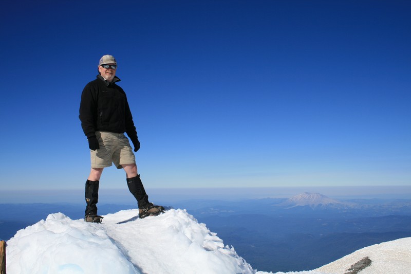
There is an old shack at summit, that was built for a lookout, but only used from 1922 to 1924. I could see only the top of the shack, but some years, late in the season, I've heard you can walk all the way into it. Climbing back to the camp is a blast. The first 1000 feet of descent is pretty easy, but the last 2000 feet down to Lunch Counter is a blast. You can glissade the 2000 feet dessent from the false summit to Lunch Counter in just a few minutes, which took almost two hours on the way up.
The total hike is only about 13 or 14 miles and about 7000 vertical feet. I highly recommend making this a two day hike. It splits up the vertical gain and gives you plenty of time to enjoy the mountain and take pictures.